Caption
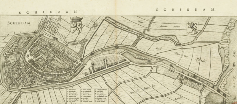
Schiedam, Map and description of Schiedam, area plan, print, Map in bird's-eye perspective and part of the description of the city of Schiedam from Blaeu's 'Toonneel der steden van de Vereenighde Nederlanden'. Above the map with the title in the upper left, the coat of arms of Holland to the right of it, and the coat of arms of Schiedam in the upper right. Below, left of the center, the legend 1-24 and the scale bar: 720 Pedes geometrici. Below the map and on the verso, Dutch text., printmaker, publisher, Amsterdam, paper, etching, engraving, letterpress printing, etching and engraving, with text in letterpress on recto and verso, height 195 mm x width 502 mm, height 515 mm x width 610 mm, Print used in: Blaeu, Johannes Willemszoon. Toonneel der steden van de Vereenighde Nederlanden. 2 volumes. Amsterdam: Johannes Willemszoon Blaeu, 1652, vol. 1., coat of arms (as symbol of the state, etc.) (city, municipal), etc.) (province, provincial), maps of cities, A sepia-toned engraved bird’s-eye view of a fortified town adjacent to a winding river, showing densely packed narrow streets and rows of buildings surrounded by a continuous defensive wall and bastions, with several bridges crossing the river to cultivated rectangular fields and parcels of land on the opposite bank; two heraldic shields with crowned lion figures appear above the landscape, and small sailing vessels are depicted on the river and along the shoreline; the engraving includes clusters of trees, linear canals, long narrow docks or quays lined with structures, and a boxed index area with small labeled entries.
Credit line
Photo12/Liszt Collection
Reference
LZT26B34_130
License type
Rights managed
Available size
44.0Mb (5.9Mb) / 19.7in x 8.7in / 5902 x 2606 (300dpi)