Sujet
Map illustrating the Battle of the Falkland Islands on 8 December 1914, (c1920). Creator: Unknown.
Légende
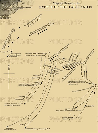
Map illustrating the Battle of the Falkland Islands on 8 December 1914, (c1920). Diagram showing movements during the Battle of the Falkland Islands, a naval engagement of the First World War, fought in the South Atlantic between the Royal Navy and the Kaiserliche Marine (Imperial German Navy). The German SMS 'Scharnhorst' was lost with all hands. From "The Great World War - A History" Volume II, edited by Frank A Mumby. [The Gresham Publishing Company Ltd, London, c1920]
Date
1914
Crédit
Photo12/Heritage Images/The Print Collector
Notre référence
HRM19F26_033
Model release
NA
Property release
NA
Licence
Droits gérés
Format disponible
62,1Mo (1,8Mo) / 33,9cm x 45,8cm / 4009 x 5414 (300dpi)